North Platte River
Glendo to almost Guernsey
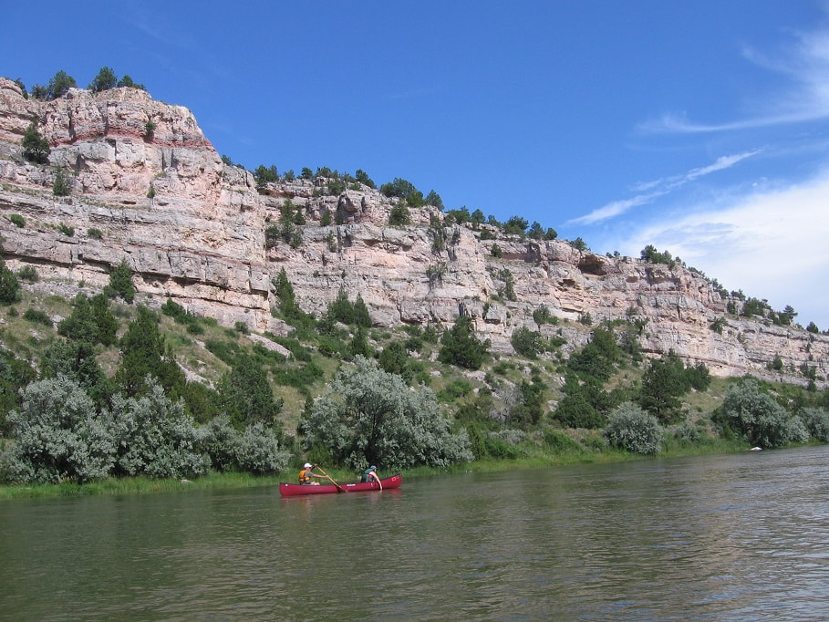
Overview: This float starts on the North Platte River near the Glendo Power Plant and finishes at the Wendover train stop just north of Guernsey Reservoir. This stretch of the North Platte flows through beautiful Wendover Canyon. The trip is about 16 miles long. At this time of year, water is released from Glendo Reservoir assuring substantial flows of around 3000-5000 cfs.
Date: This year's float is on Saturday, August 10th, 2024 so you camp on August 9th and float on August 10th. There is an optional potluck the evening of August 10th. You should make reservations for the 9th and 10th if you plan to attend the potluck.
Hosts: The hosts this year are:
Poudre Paddlers' Host: Craig Godbout, [email protected]
Rocky Mountain Canoe Club Host: Roger Faaborg, [email protected] (All RMCC members are welcome. This is not an ACA event)
Rocky Mountain Sea Kayak Club: Leslie Copeland Taylor, [email protected]
If you want to attend, please notify the appropriate host above and they will add you to the list.
Current River Flow:
River Flow below Glendo Reservoir
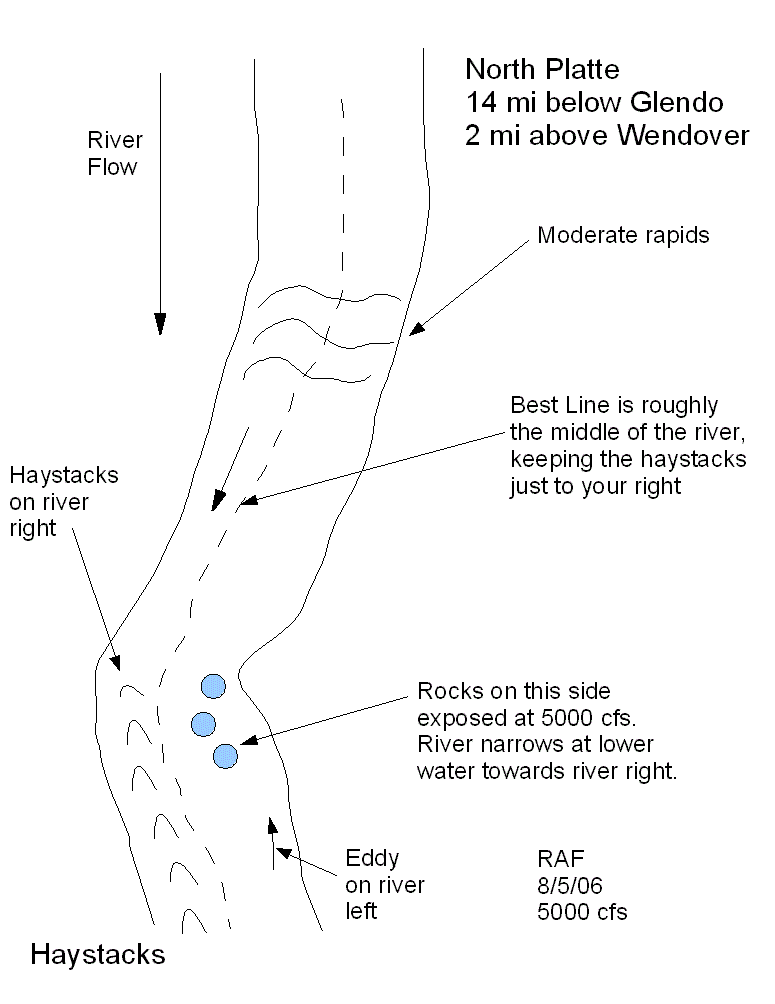
Class: Class I+ with one optional wave train that is a class II at high flows. The river in this stretch is wide with ample opportunity to avoid rocks and strainers, but it does move swiftly. Prior moving water experience is required. The optional wave train (the haystacks) are on river right and have a large eddy on river left (See the map on the last page). The easiest passage is to stay left of the haystacks, stay right of the rocks, and be ready to enter the very strong eddy on the left, which can flip you if you are not prepared. For the more adventurous, you can go through the big waves of the haystacks, enter the strong eddy on river left, and get in line to run them again. At flows of 3000 cfs and below the haystacks are small. At flows around 5000 cfs and above, they become quite large. At very low flows, 1000 – 2000 cfs, the waves above the haystacks become larger while the haystacks become smaller.
Important!: Most boats used in Wyoming must have the Game & Fish Invasive Species Decal and all boats must be inspected when entering Wyoming.
1. Wyoming Decal: If you are floating a boat in Wyoming, you need to purchase an invasive species decal. Only inflatables of 10 feet or less are exempt. You can purchase the decal for $15.00 at the link below or at any store in Wyoming that sells fishing licenses.
Invasive Species Decal
If you order online, you need to have a printer so you can print a receipt that is good for 30 days. They will mail you the actual decal within 10 days. You need a separate sticker for each boat you float in Wyoming. The money goes to trying to keep invasive species out of Wyoming.
2. Wyoming Inspection: All boats have to stop and be inspected as they enter the state during the summer months. That includes canoes and kayaks. The inspection stations are only open certain hours, so you will have to plan your trips accordingly. This will affect all floats on the North Platte. If you plan on driving up I-25 to Cheyenne, then the inspection station is in the welcome center parking lot, a few miles north of the border, at 5611 High Plains road. They are usually open during the summer from 6:00 am to 9:00 pm.
Boat Inspection Locations
Camping: If you live close to Glendo, you could possibly do the float without camping, but since we start very early Saturday (7:30am), most people will camp at least Friday night. If you plan to attend the potluck, then you need to camp Friday and Saturday nights. There is a vehicle charge to enter the State Park and also a camping fee. In 2024, the camping fee per night was $18 and the additional entrance fee was $8 per vehicle. We tend to camp near the low numbers, like campsite 9, 11, etc. near the cliff. All campsites at Two Moon campground are reserved and you can make reservations at:
https://wyoparks.wyo.gov/index.php/reservations-glendo
If you can't reserve a spot at Two Moon, try Shelter Point Campground or Sagebrush Campground.
Safety:
PFDs are required on all Poudre Paddler events
Bring rain clothing
Bring a river whistle
Bring extra clothing in a dry bag
Drink lots of water
Do not tie children or pets to the boat
Rescue people first, equipment second
Keep between lead boat and sweep boat
Use sunscreen, hat, and sunglasses
Bring a throw rope if you have one
Bring a personal first aid kit if you have one
Bring a cell phone if you have one (and keep it in a sealed bag/container)
There are rattlesnakes in this area, so watch where you step
Bring lunch, drinks and enough snacks for the whole day
Itinerary:
Friday: Since we start very early Saturday morning (7:30 am), it is best to drive up Friday and camp at at Two Moon Campground. If you have time, you may want to paddle in Glendo Reservoir. Glendo State Park Information. You could also drive up early Saturday morning.
Directions to Two Moon Campground: Drive I-25 north through Cheyenne, Chugwater, Wheatland, and exit at Glendo, Exit 111. (Chugwater has a great ice cream shop on the far east side of town. Take the 1st Chugwater exit and take a right. Go to the end of the road to the “T” and take a left. The shop and parking lot are immediately on your left). Allow about 3 hours travel time from Fort Collins (Downtown) to Glendo, Wyoming. In Glendo, follow the signs to Glendo State Park. You'll be going south on the Glendo Park Road. See the map that follows below. The Glendo Park Road is on the southeast corner of town. If you end up leaving town on 319, go back.
Continue driving past the marina and headquarters, until you get to Two Moon Campground on the left. Look for canoes or kayaks and these people will be Poudre Paddlers.
8:00 pm, Friday, the day before the float. We will have a quick meeting at the campsite with the "Poudre Paddler" sign to discuss the shuttle in the morning at tent site 11 in Two Moon.
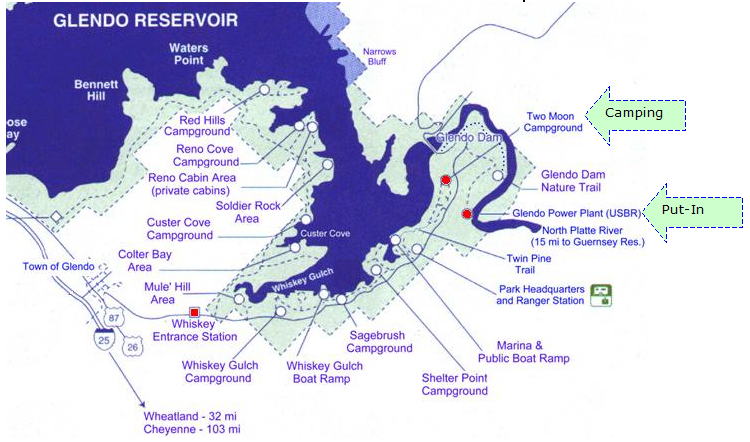
7:30 am, the day of the float. Drive to the put in. To get to the put in, leave the Two Moon Campground and turn left. Head northeast and turn right on the Power Plant and Wetlands Road. (Don't miss the turn off to the Power plant or you will end up at the wrong place and no one will be there) Follow this road down the hill where you will turn a sharp left in front of the power plant. Take the next right. In 2023 the causeway across the old river bed was closed to traffic and is still closed in 2024. We launch into the reeds by going over the guardrail. The guardrail is somewhat sharp so lift your boats over the guardrail. Park in the small parking lot before the causeway.
7:30 am, the day of the float. Drive to the put in. To get to the put in, leave the Two Moon Campground and turn left. Head northeast and turn right on the Power Plant and Wetlands Road. (Don't miss the turn off to the Power plant or you will end up at the wrong place and no one will be there) Follow this road down the hill where you will turn a sharp left in front of the power plant. Take the next right. In 2023 the causeway across the old river bed was closed to traffic and is still closed in 2024. We launch into the reeds by going over the guardrail. The guardrail is somewhat sharp so lift your boats over the guardrail. Park in the small parking lot before the causeway.
This shows the Two Moon campground and the road to the put-in. The white box area is shown in the photo below.
This shows the guardrail and the path to the water. After entering the water, we will regroup at the boat ramp on river left.
One person per vehicle will drive their vehicle to the take out. The others will stay by the boats. Make sure you have as a minimum: canoe, paddles, PFDs, water, hat, rain suit or rain poncho, jacket, lunch, and sunscreen. (Optional items: dry bag with change of clothes in case you decide to play in the haystacks or go swimming).
The shuttle takes a long time and there isn't much shade for those waiting by the boats. It would be nice to set up a canopy or have umbrellas. Definitely apply sunscreen. You may want to plan games for children to keep them busy during the wait. The other option is for most people to stay in the shade at the camp and then take them to the boats when the shuttle drivers return. At least one person needs to stay with the boats and equipment.
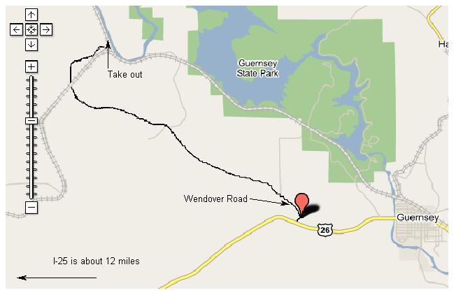
8:15 am, the day of the float. Start the shuttle to the takeout. One person per vehicle will drive their vehicle to the take out. Drive from Glendo State Park back to I-25 (7 miles). Head south on I-25 for about 19 miles to Left Exit 92 "Guernsey." Take US 26 east toward Wendover. After about 12 miles you will see Wendover Road on the left. There is also a sign on the right that says "River Access." Take Wendover Road for 8 miles. Follow all the way until it joins Cottonwood Road which is right before the RR tracks. Cross the tracks until you see a sign on your left for Parking (it's on a small hill). Park all vehicles there. The take out is just down the hill under the RR bridge. You can drive down to the river to get your boat at the end of the trip. Total one way distance is 46 miles. Some cars, as few as possible, will have to take the drivers back to the put in. These vehicles should be those which can take the maximum number of people and can't carry many boats. Drivers should put their car keys in a safe place. A zippered pants pocket or zippered PFD pocket works well.
If you show up late and miss the shuttle, just leave your car at the put-in and we will try to get you and your boat back to Glendo after the float.
10:00 - 11:00 am, the day of the float. Quick safety review and then we finally hit the water. There are some rapids right at the start, but that will wake you up after sitting in the sun waiting for the shuttle. If you want to avoid the rapids, stay to the left of center. Try not to pass the lead boat or get too far behind the sweep boat. The river does have islands and channels, so it is easy to get behind or ahead. Just try to keep another boat in view.
12:00 - 1:00 pm, the day of the float. Stop for lunch on Lunch Island (also known as Cowpie Island). This island is in the middle of the river and the lead boat will stop there, so it is hard to miss. The river splits into two channels, but they all come together right before this island. We will have lunch and if it is a warm day, we can test our PFDs and throw ropes.
The Haystacks!
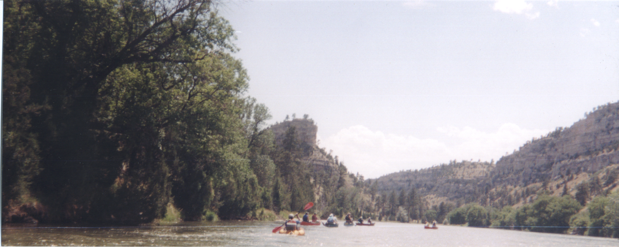
2:00 - 3:00 pm, the day of the float. After you go around the Big Bend, (see map below), stay to the center as you paddle down the river. Look for a butte on river left and then the river turns right and runs downhill. The haystacks are on river right and there are rocks or pour-overs on river left, so you need to go in between them and then enter the eddy on river left. See the picture below and the drawing on the last page. The haystacks are also known as "standing waves" and are there due to geography, not rocks. The fast downhill water meets the slow flat water and makes about 8 waves that start big and end small. We usually stop and paddle and swim through them several times. The haystacks are small at flows of 3000 cfs and lower and can be floated by everyone. At flows around 5000 cfs and higher the haystacks become quite large.
IMPORTANT: We will all eddy out on river left just before the haystacks. If the flow is above 3000 cfs, 2 rescue boats will go first and then the other boats will follow at intervals so we don't have a lot of swimmers at once. It is not unusual for boats to get flipped at the haystacks at high flows. Make sure everything is tied down tight to your boat. If you use a cord rather than a tie down, keep the cord very short, for safety’s sake. Everything not waterproof should be left in the car, or put inside a dry bag, secured to the boat. Get Croakies or other cords for your glasses or sunglasses. Make sure that your footwear will stay on if you swim. You can walk your boat around the haystacks if you are uncomfortable. Or put your gear on shore before you run the haystacks.
View of the river and butte, just before the haystacks
4:00 - 5:00 pm, the day of the float. About 1-2 minutes after leaving Wendover Canyon, look for the RED house on river left and the railroad bridge on river right. Take your boat out directly underneath the railroad bridge.
We'll keep an eye on the weather and push ahead of schedule if needed.
Those paddlers whose cars are at Glendo will need a ride (including their boat) back to Glendo. The rest can return to Glendo for the Saturday evening potluck or head for home. Drive safely.
7:00 – Whenever pm, the day of the float. Group pot-luck at Glendo.
Please tell us if you are coming on this float, especially if you are doing the potluck Saturday evening. The host organizes the trip, but each family is responsible for their own personal safety.
Some Phone Numbers:
Wheatland Hospital (Platte County Memorial Hospital), 201 14th Street, Wheatland, (307) 322-3636
Glendo State Park (307) 735 4433
Wheatland Police, 951 Water Street, (307) 322-2141
Fort Collins, towing, Kramer & Houston Towing, 970-493-3375
Platte County Sheriff-Wheatland (307) 322-2331
Lee’s Towing, Glendo, WY (307) 331-7250
Big Al's Towing & Recovery, Cheyenne, WY (307) 632-6999
Affordable Towing and Recovery, Cheyenne, WY (307) 256-2254
How to get through the Haystacks!
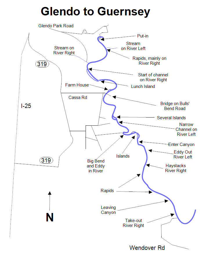
Keeping track of where you are on the river.
Below is a photo of a tandem canoe going through the haystacks. The paddlers appear to be "grabbing the gunnels." This is not recommended, as your paddles should be in the water providing a brace.
