
Six Mile Gap to Treasure Island Float
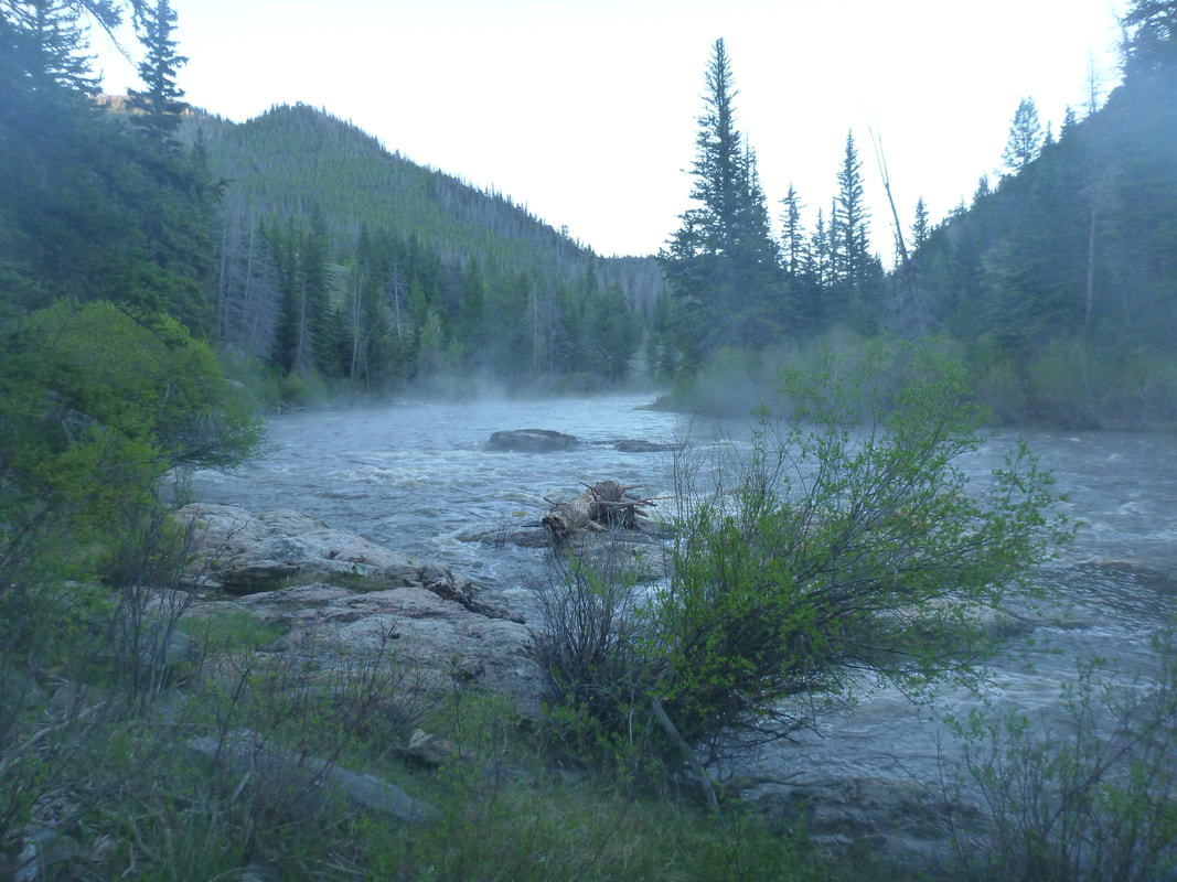
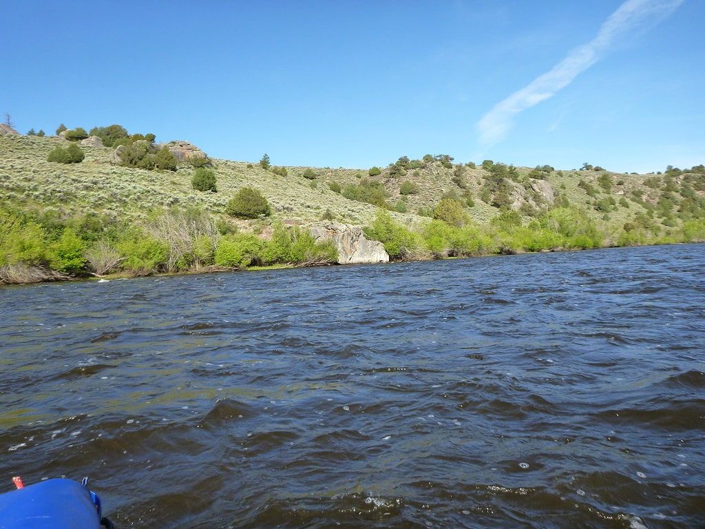
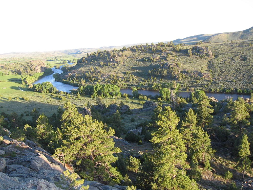
View from Deadwater South Campground (Taken before the Mullen fire)
This is the great, but short, river trip that Ken Bauer hosted for about 30 years. We camp 2 nights on the river and paddle for three days, so the entire trip takes 3 days. This is a good trip to start whitewater camping along a river. If you forget something, you will only miss it for 2 nights. The difference this year is that the Mullen fire in 2020 burned parts of this area. So, the photo above may look different.
Date: 9:30 am, Friday, May 31, 2024, meet in the parking lot at the top of the trail at Six Mile Gap campground. We start late to give people the opportunity to drive to Wyoming Friday morning. Allow about 3 hours driving time. If this float has to be postponed due to weather or high water, the trip will be delayed until June 14.
Overview: We float a total of about 38 miles from Six Mile Gap campground to Treasure Island. On Friday we float from Six Mile Gap campground to Deadwater South campground, about 6 miles. On Saturday we float to the second campground, about 17 miles. On Sunday we float 15 miles to Treasure Island, the take-out. We start out in the Platte River Wilderness area, which is part of the Medicine Bow National Forest. This is a beautiful pine forest area. We end up floating through ranch land where the river is lined with cottonwoods. We have seen moose on previous floats and the fishing is generally quite good. We start the float at an elevation of about 8,000 feet, so be prepared for cooler weather.
Class: Class II. Douglas Rapid is probably a III at higher water levels. So you should be able to float Filter Plant on the Poudre before going on this trip. At high flows, around 3000 cfs or more, tandem canoes tend to swamp from reflection waves. Whitewater canoes do fine. At low flows around 500 cfs, there are a lot of rocks to dodge. The best level for canoes is probably around 1500-2000 cfs. At 1500 the rocks are mostly under water and the waves are not too high. Boats filled with camping gear are more stable in big waves, but don't respond as quickly.
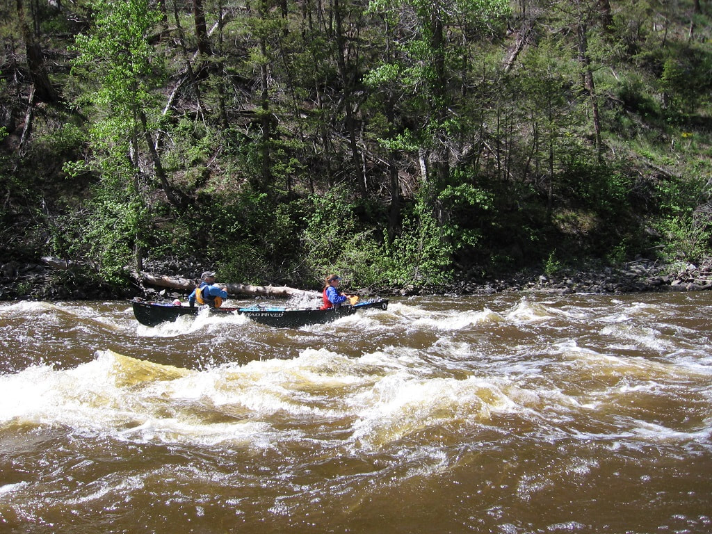
A tandem canoe with Brie (bow) & Mike (stern) Koliha going through Douglas Rapids
Wyoming Decal: If you are floating a boat in Wyoming, you need to purchase an invasive species decal. Only inflatables of 10 feet or less are exempt. You can purchase the decal for $15.00 at this link or at any store in Wyoming that sells fishing licenses.
https://wgfapps.wyo.gov/elso/elsoaiswelcome.aspx
If you order online, you need to have a printer so you can print a receipt that is good for 15 days. They will mail you the actual decal within 10 days. We were checked on the North Platte river once. You need a separate sticker for each boat you float in Wyoming. The money goes to trying to keep invasive species out of Wyoming, which is important.
Wyoming Inspection: All boats have to stop and be inspected as they enter the state during the summer months. That includes canoes and kayaks. The inspection stations are only open certain hours, so you will have to plan your trips accordingly. This will affect all floats on the North Platte. If you plan on driving up 287 to Laramie, then the inspection station is at the Port of Entry, 1 mile south of Laramie. Ken Bauer, who lives in Longmont, is an AIS inspector and can inspect your boat. His email is [email protected]. Just make sure to read the requirements and have a clean boat.
More information to help you find an inspection station is available at:
https://wgfd.wyo.gov/fishing-boating/aquatic-invasive-species-prevention/ais-inspection-locations
Waste: The rule is to "pack it in, pack it out" and that includes human waste. You should bring an ECO Safe toilet or use wag bags if you prefer and dispose of them properly when you get off the river.
Food: We are each responsible for our own food and don't do group cooking on this short trip.
Bears: You should bring bear proof containers for your food. We have never had trouble with bears on this float, but the Mullen Fire might have damaged the bear's food sources. In 2023, the Six Mile Campground was closed because of an aggressive bear.
Water: Most of the time, the North Platte is clear enough to filter. It gets muddy after a heavy rain or quickly melting snow. I generally just bring my own water for the 3 days. When I asked Ken about the water quality, he said it was pretty good considering 10,000 cows probably peed in it.
Gear: The water is very cold. Bring your dry suits or wet suits, if you have them. If not, bring changes of clothing. Helmets should be worn until we are past Douglas Rapids. There are often afternoon showers, so a group rain tarp is also a good idea.
Camping in the Area: Six Mile Campground has 9 sites. 6 sites are by reservation on recreation.gov and 3 are first come first serve. If you can sleep in your vehicle, you can camp at the Six Mile Trailhead parking lot, or Routt Access parking lot. Right before entering Six Mile Campground, there is a road going south up a hill where people camp. It is on BLM land and far enough in that it is legal to camp there. Obviously, there are no facilities. In 2024, Six Mile Campground was $20 per night. If you leave your vehicle at the trailhead, the cost is $5 per night.
Itinerary:
Early Friday Morning: The drive from Northern Colorado to Six Mile Gap campground takes about 3 hours. Take 287 to Laramie. Stop at the Port of Entry 1 mile south of Laramie to get your boat inspected. Go west on I-80 and immediately exit on Wyoming Highway 130 Snowy Range Road. Then go south on Highway 230 from Laramie, which goes back to Colorado and becomes Highway 127. When 127 and 125 cross, take 125 north towards Saratoga. As you leave Colorado, 125 turns back into 230. Follow 230 north. About 6 miles north of the Colorado Wyoming border is the road to Six Mile Gap campground. The road is 492 or Six Mile Road and it leads to the campground. There is a parking lot behind the campground that we will use to unload our boats. Make sure you go to Six Mile Gap and not Routt. Routt is the river access point in Colorado and Six Mile is further up the road in Wyoming. Cross the border before you start looking for the river access signs.
Early Friday Morning: The drive from Northern Colorado to Six Mile Gap campground takes about 3 hours. Take 287 to Laramie. Stop at the Port of Entry 1 mile south of Laramie to get your boat inspected. Go west on I-80 and immediately exit on Wyoming Highway 130 Snowy Range Road. Then go south on Highway 230 from Laramie, which goes back to Colorado and becomes Highway 127. When 127 and 125 cross, take 125 north towards Saratoga. As you leave Colorado, 125 turns back into 230. Follow 230 north. About 6 miles north of the Colorado Wyoming border is the road to Six Mile Gap campground. The road is 492 or Six Mile Road and it leads to the campground. There is a parking lot behind the campground that we will use to unload our boats. Make sure you go to Six Mile Gap and not Routt. Routt is the river access point in Colorado and Six Mile is further up the road in Wyoming. Cross the border before you start looking for the river access signs.
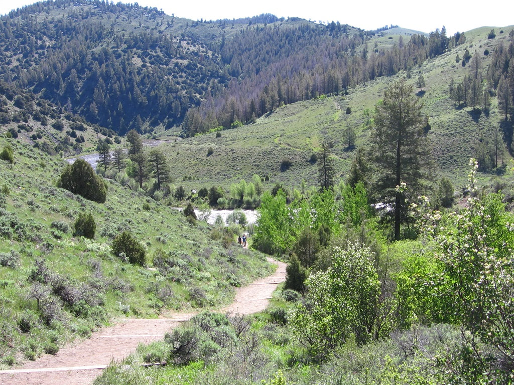
Long path from the parking lot to the river at Six Mile Gap campground
9:30 am, Friday: Park in the lot at the top of the trail and unload your equipment and boat. Carrying everything down to the water and rig your boats. We have to carry the boats and all the equipment down this long trail. You can't use your wheels, because we are in a wilderness area.
11:00 am, Friday: One person per car will drive the shuttle to Treasure Island. The others will continue rigging the boats. The shuttle is about 36 miles and takes about 45 minutes each way. But the drivers sometime stop and buy lunch in Encampment.
1:00 pm, Friday: We will finish lunch on shore, go over some safety rules, and then finally start paddling. About 6 miles down the river is our campground, Deadwater South. If it is full, we will find another place. It is a good idea to keep track of where you are. There is a waterfall on river right near the Waterfall South campground. All this land is public until we get to the A-A Ranch and beyond that, it is mostly private. The campgrounds used to have wooden posts, but some were damaged during the flooding. The rock pattern you should look for to recognize Deadwater South is shown on the first photo of this Web page and the photo below.
Look for this rock pattern and you will be at Deadwater South campground
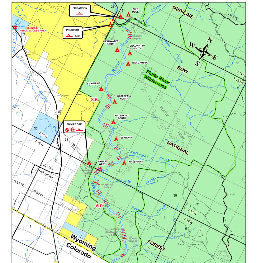
Map of North Platte from Six Mile Gap to Prospect
The maps shown are available in this file: Printable Upper North Platte River Float Map
In 2022 the Wyoming Game and Fish Department came out with a new map. This file can also be downloaded here: 2022 Map
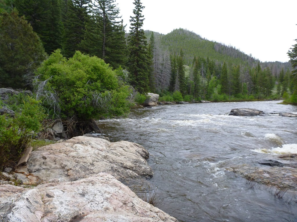
Saturday: After sleeping off the margaritas of last night, we will paddle around the bend and stop to scout Douglas Rapids on river right. You can hear the rapids and there is a big eddy on river right where you can tie your boats and walk up to the trail. This is the biggest rapid that we go through so scouting it helps to build up the drama. After conquering the rapid, we will float past Pickaroon campground on river right and Prospect on river left. Both are accessible by car and have pit toilets. The road into Prospect is a terrible jeep road. The road to Pickaroon is a very long drive through the backcountry. Proceeding down the river we pass A-A Ranch, then a bridge, then Big Creek enters on river left and Big Creek campground is on river right. After many miles we float under French Creek road. This tells us we are about 1-2 miles to camp. The camp is on a flat area beneath an impressive rock formation. This camp is on public land. Property boundaries are marked along the river by red and blue squares. Property behind a red square is private and behind a blue square is public.
In 2022 the Wyoming Game and Fish Department came out with a new map. This file can also be downloaded here: 2022 Map
Saturday: After sleeping off the margaritas of last night, we will paddle around the bend and stop to scout Douglas Rapids on river right. You can hear the rapids and there is a big eddy on river right where you can tie your boats and walk up to the trail. This is the biggest rapid that we go through so scouting it helps to build up the drama. After conquering the rapid, we will float past Pickaroon campground on river right and Prospect on river left. Both are accessible by car and have pit toilets. The road into Prospect is a terrible jeep road. The road to Pickaroon is a very long drive through the backcountry. Proceeding down the river we pass A-A Ranch, then a bridge, then Big Creek enters on river left and Big Creek campground is on river right. After many miles we float under French Creek road. This tells us we are about 1-2 miles to camp. The camp is on a flat area beneath an impressive rock formation. This camp is on public land. Property boundaries are marked along the river by red and blue squares. Property behind a red square is private and behind a blue square is public.
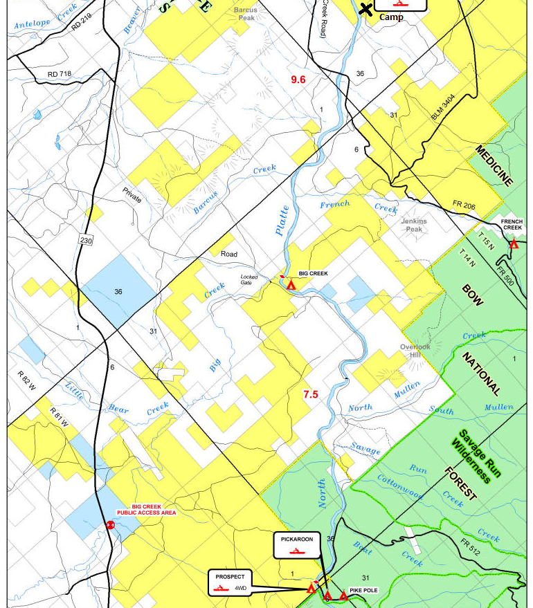
Map of North Platte from Prospect to camp near the rocks
After going under the French Creek Road bridge, start looking for rock formations on river left. As soon as the rock shown above comes into view, start looking for the rocks on the photo below. The camp is on river right, but the rocks used to find the camp are on river left.

You are at the right place if you can find the "kitchen" shown below.

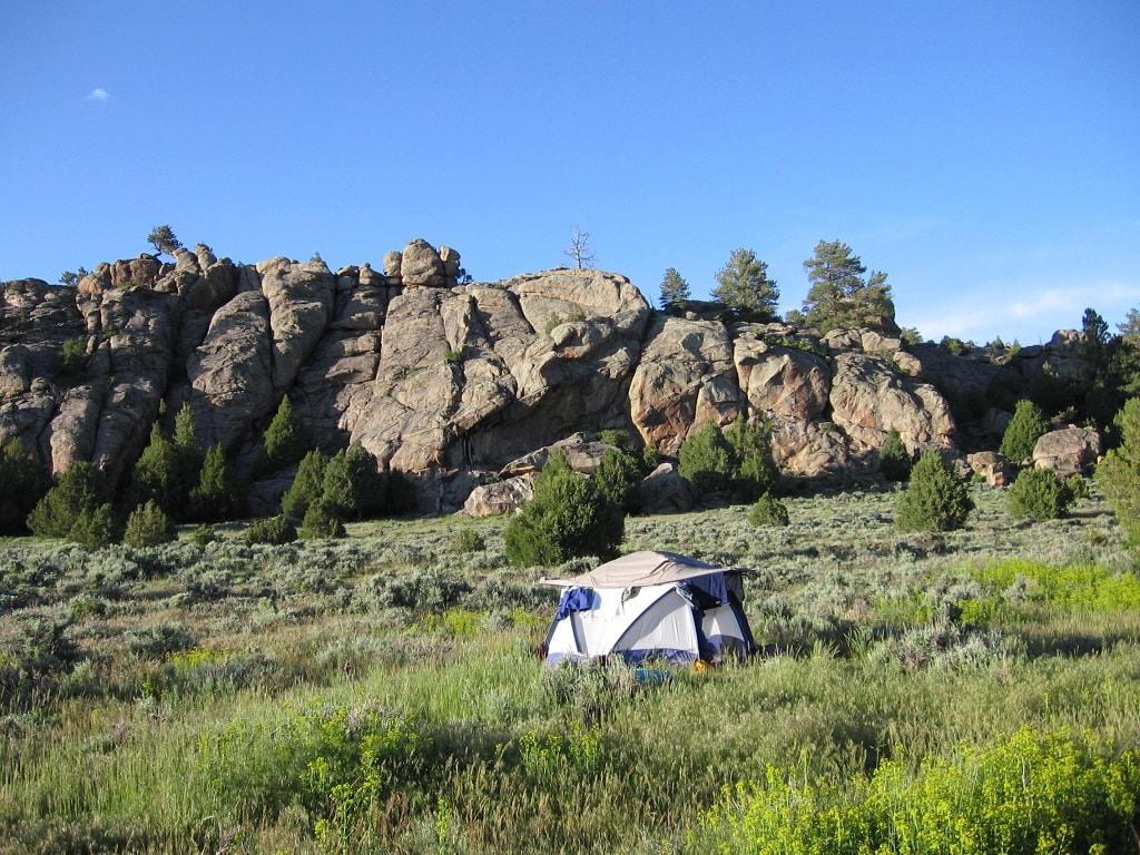
Camp near the large rock formation.
View from the top of the rocks.
Sunday: Heading downriver, we will pass Bennett Peak campground. Commercial outfitters float from Bennett Peak to Treasure Island or continue to Saratoga. Much of the land is now private. We will pass under French Creek Road and then travel many miles until the Encampment River enters on river left. Approaching Treasure Island, you need to keep left or you will float right past the take-out. If you get to Highway 130, you have gone too far.
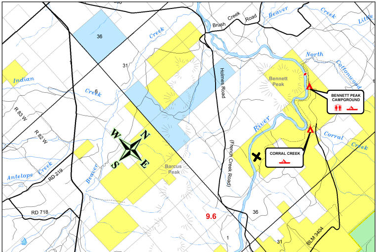
Above is a map of the North Platte from our camp (X) to Bennett Peak campground.
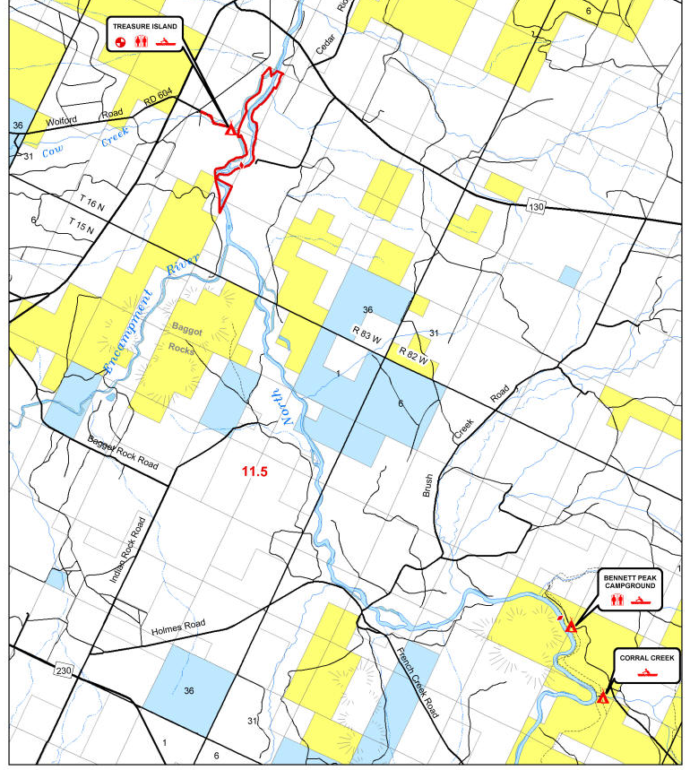
Map of North Platte from Bennett Peak to Treasure Island.
Hobo Hot Springs: After loading the equipment into the cars, we generally drive to Saratoga and go to the hot springs. This is followed by a shower and then lunch in town. It is good to support these small communities. After lunch we drive back to Colorado.
Contact: Roger Faaborg is the host for this float. He has been doing this float for about 10 years prior to the pandemic. His email is [email protected]. Make sure you notify the host if you are interested so he can contact you about any changes to the trip.
Some Phone Numbers:
Platte Valley Medical Clinic, 1208 S. River Street, (307) 326-8381
Saratoga Police, 110 E. Spring, (307) 326-8316
Saratoga Towing, 305 N. State Street, (307) 326-5700
Walden, towing, North Park Towing, 970-723-4768
Laramie, towing, L&W Towing, (307) 745 8316
Fort Collins, towing, Kramer&Houston Towing, 970-493-3375